Cane Creek Mountains Natural Area • New Trails Now Open!
Cane Creek Mountains Natural Area is a new nature park that provides public access to Alamance County’s largest state-significant natural heritage area. Hikers will enjoy rolling piedmont hills, abundant creeks and streams, and some of the best views in the County.
Cane Creek Mountains Natural Area is located in the Cane Creek Mountains Range, a Piedmont Monadnock range that covers much of the southwest quadrant of Alamance County. The mountain range is also home to the highest peak in North Carolina east of Greensboro at 987 feet.
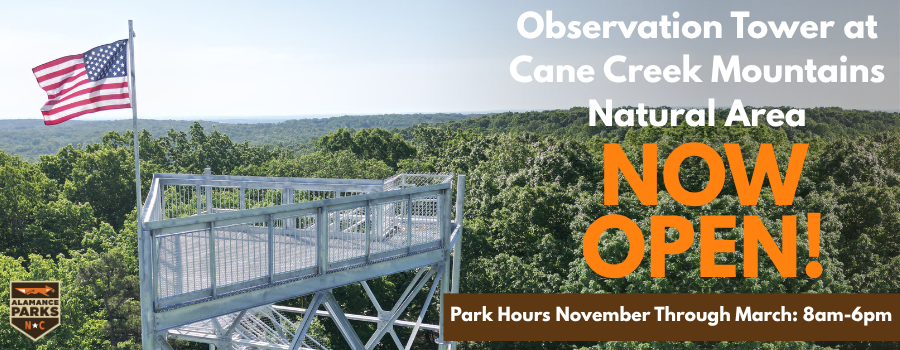
Monadnock Lookout Tower
Climb up. Look out. Take it all in.
The Monadnock Lookout Tower is now open! The Monadnock Lookout Tower offers sweeping, 360-degree views. Climb 80 feet to stand just above the tree line to experience a bird’s-eye view of the natural beauty of rolling hills and lush forests that Alamance County has to offer. Can’t make it to the top? Check out a video of the tower here.
Phase 1: Pine Hill Trailhead
- Address: 5075 Bass Mountain Rd, Snow Camp, NC 27349
- Features 4.5 miles of hiking trail including the Northern Approach, Heartleaf Loop, and Longleaf Loop Trails (more information about each trail is available here)
- Offers four drive-in primitive campsites available for reservation. Click Here to visit our reservation site, RecDesk.
- Monadnock Lookout Tower can be accessed on the Northern Approach Trail (trail difficulty = strenuous).
Phase 2: Oak Hill Trailhead
- Address: 5545 Bass Mountain Road, Snow Camp, NC 27349
- Features 5.9 miles of hiking trail including the Pioneer Camp Trail and Lookout Trail, and a wildlife observation area (more information about each trail is available here)
- Monadnock Lookout Tower can be accessed on the Lookout Trail (trail difficulty = moderate).
Phase 3: Peach Orchard Trailhead
- Address: 5706 Mt Hermon Rock Creek Rd, Snow Camp, NC 27349
- Features 4.85 miles of hiking trail including the Lark Loop, Mountainview Trail and Varnals Creek Trail.
The development of the park will continue over the next several years. Upon completion, the Cane Creek Mountains Natural Area will total over 1,000 acres and include an observation tower, camping facilities, wildlife observation areas, and more.
Click Here to see a map of the park.
